

The Use of the LiDAR System on the West Island
Benoît Péloquin Arpenteur-géomètre inc.
A Project in Sight?
At Benoît Péloquin Arpenteur-géomètre inc., we will accompany you in all your projects requiring the acquisition of data using the LiDAR system.
Ask for an online quote!
The LiDAR System
The word LiDAR stands for "Light Detection and Ranging", which is remote sensing by laser.
The LiDAR measurement method opens the door to many applications. LiDAR allows billions of measurements to be taken in a three-dimensional environment for the area being studied. When processing data, the relevant information is extracted, allowing the customer to make the best decisions, to see the facts or to develop the best possible project.
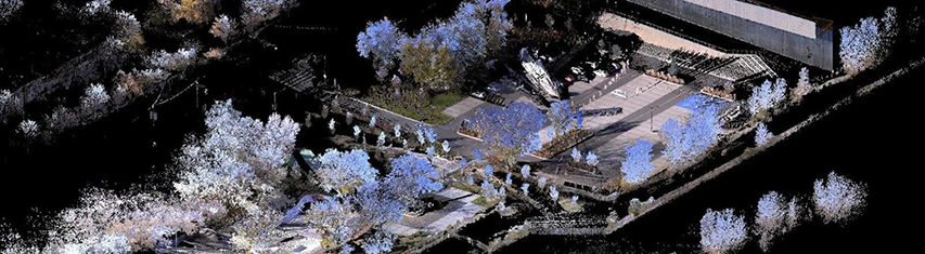
Visualization of Data from a Terrestrial LiDAR Survey (3D Scanner).
There are many applications. Surveying using the LiDAR method allows any project requiring precise knowledge of an environment. Here are just some of the many possibilities:
Volumetry
LiDAR is used to evaluate the volume of piles of material. For example, we can determine the amount of earth when a company wants to know how much earth remains unsold at the end of the year, or calculate the number of loads of earth transported. You can also call on our services to assess the volume of material in a garbage dump.
Architectural Project
LiDAR can provide a three-dimensional overview of an existing environment, such as a building requiring complex renovations, for example. Future renovations can then be inserted into this model, giving the benefit of viewing the final project before it is even built. This makes it easier to anticipate possible deficiencies.
Calculation of Contours
The creation of contours in an urban or natural environment is possible thanks to LiDAR, which allows us to cover a large territory. The client is then able to see floodplains, slopes, streams and other topics of interest once the information is analyzed by the land surveyor.
There are different types of LiDAR measurement.
The Aerial LiDAR
Measurement during an aerial LiDAR survey is carried out using an aircraft on which a 3D laser scanner has been installed. The aircraft makes several passes over the area of interest. The data thus collected are then processed and analyzed.
The Terrestrial LiDAR
Measurement in an aerial LiDAR survey is done with a mobile 3D laser scanner. It can be used outside and inside a building.
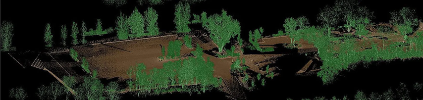
Visualization of Different Layers of Data from a Terrestrial LiDAR Survey (3D Scanner).
The possibilities are very vast with this technology – take advantage of it! Contact Us to know how LiDAR can be of use for your project.
We are hiring !
Apply today